Anglezarke Moor
During the mini heatwave I started exploring the moors around Anglezarke a bit more. This was mostly because I didn't have the energy to hike up to the moors from lower ground such as White Coppice or Brinscall and could just drive up to the edge of the open moor at Anglezarke and then walk a short distance over relatively flat ground to get out into, what at least felt like, remote places.
With the heatwave passed and a return to normality (i.e. <20C temps, overcast skies, the constant threat of rain, you know, standard summer weather here in the Northwest of England) I decided to explore more deeply into this little patch of moorland, approaching places I've visited many times before, such as Round Loaf, but from a different starting point and getting a bit more insight into how these places knit together.
This set was taken on two separate walks around broadly the same area, both starting and ending near Jepsons Gate farm.
All images taken handheld with the Fujifilm GFX100S and 35-70 or 100-200 lenses (yes, my lens collection has doubled! My bank balance has been less fortunate). Processed from single raw files in Capture One Pro 23.
1. Jepsons Gate
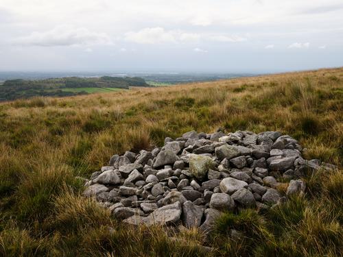
I've been half heartedly searching for Jepsons Gate for a while now. It's labelled on the OS maps close to Pikestones, but its exact location isn't shown. Having recently found a blog containing grid coordinates for the site, I dropped a marker into my Garmin, ready for the next time I would be walking in the area. Sure enough, having walked past Pikestones and out onto the open moor, then following a vague trod across the moor in the general direction I arrived at the spot marked by this neat and tidy cairn. Finding information on Jepsons Gate is a bit like pulling hens teeth, so at this point I still have no idea what the significance of the site is or its relationship to other ancient sites on the moors such as the nearby Pikestones and the slightly more distant Round Loaf. I don't even know if it's "Jepsons Gate" or "Jepson's Gate" i.e. whether the name is possessive or not. One thing I do know is there's definitely not a gate there, just a pretty modern looking and well maintained cairn that appears to change its design from time to time, judging by other pictures I've seen.

2. Storms Over Chorley
Jepsons Gate does afford a rather nice view of Healey Nab and Chorley beyond. At this point, there was a bit of a break in the leaden skies, illuminating the mild storm that was sitting over the former cotton town.

3. Rivington
Looking in the other direction, we get a nice view of Rivington. The wooded side of the hill hides the terraced gardens, with just the odd bit of masonry poking through the canopy and of course The Pigeon Tower on the top left of the trees completely giving the game away. The row of trees in the foreground is the edge of a plantation that sits alongside Pikestones.

4. Shooting Huts?
Following along the edge of the plantation, I quickly arrived at a steep valley containing a stream that eventually becomes Lead Mines Clough further downhill. A little way downstream this is joined by a tributary emerging from the moors and labelled on the OS map as Limestone Brook. I crossed the stream and followed this tributary out onto the moors, eventually passing this little cluster of shaped stones. Referring once more to the OS map, it appears this was once the location of Shooting Huts, although you could easily dismiss it as just a few rocks in the grass, as whoever dismantled them really went to town.

5. The Red Weed
Following the boggy path higher onto Anglezarke Moor I eventually passed the lower end of Devil's Ditch and crossed the dried river bed beyond it. I say dried, it was really kind of boggy to be honest, so crossing it was quite a careful process. On the far side the moorland heather was on the wane. Still clinging to a bit of its colour, but definitely on its last legs until next year. It's a shame I didn't make it onto this part of the moors a few weeks back when it was at its peak, I bet it looked spectacular. In the distance, you can see my immediate destination, Round Loaf. Although I've explored this part of the moors over the past few years, I've never previously approached Round Loaf from the Anglezarke side, so it was nice to finally join up the dots in my head and have another option for accessing the moors rather than always entering via White Coppice.

6. Winter Hill from The Moors
From Round Loaf I crossed the moor to Hurst Hill, stopping mid way to take this shot of Winter Hill.

7. The Summit of Hurst Hill
This was taken as I approached the summit cairn of Hurst Hill. Harrock Hill can be seen in the distance to the right of the cairn and faintly in the distance you can just make out bumpy profile of The Great Orm.

8. A Hole In The Wall
This shot was taken after sunset in the field above Lead Mines Clough.


